Showing posts with label Regency. Show all posts

Southeast Minahasa Regency

Southeast Minahasa (Mitra) regency is a new regency in the province of North Sulawesi, Indonesia, with a capital of Ratahan which is a division of South Minahasa regency.

May 23, 2007 in Manado has been inaugurated by the Minister of Home Affairs Widodo AS Ad Interim along with three other districts, namely North Bolaang Mongondow , Kotamobagu City and County Tagulandang Biaro Siau Island (Sitaro).


(New icon)
Soutjeast Minahasa Regency Logo

(Old icon)
southeast minahasa regency

This area  (Southeast Minahasa- Mitra), North Sulawesi, is an area with an excellent tourism potential.
as Bentenan beach, Lakban, Hais, and various other interesting places.

previously occurred after the turn of the logo area then this area is also headed to the direction of change for the better. some splitting of districts and villages has become proof that good democracy has done in this area.

I live in this regency.
especially district tombatu.


Go Southeast Minahasa (Mitra).


You can check many tourism site of this Regency in here or Tourism Page.


East Bolaang Mongondow Regency

East Bolaang Mongondow (Boltim)  is a Regency in North Sulawesi province,  with the central government located in Tutuyan. This district was formed pursuant to Act No. 29 of 2008, which is a division of Bolaang Mongondow. Inauguration by Minister of Home Affairs, Mardiyanto, in Manado on Tuesday, September 30, 2008.

Districts in Boltim :

   1. Tutuyan
   2. Kotabunan
   3. Nuangan
   4. Modayag
   5. West Modayag
Boltim, Tutuyan

Tourism Featured :

Tourism Objects namely Mooat Lake, Mount Float, Pineapple Island, Lake Togid, (lake Motongkad)

Boltim has a strategic location is between Kotamobagu and directly adjacent to the Southeast Minahasa regency. Boltim also has a vast agricultural potential, whether of the farm and fishery. Sources of income from farming communities in the form of coconut, cloves, cocoa, rice, fish and others. But all was not well-managed and maximized.

This a new regency in North Sulawesi.
You can check many tourism site of this Regency in here or Tourism Page.


Bolaang Mongondow Regency

Bolmong Regency

Bolaang Mongondow are districts in the province of North Sulawesi, Indonesia. Its capital is Kotamobagu. Ethnic majority in this district is Mongondow Tribe. Indigenous mother tongues in this area is Language Mongondow.
Region Bolaang Mongondow has undergone a number of blooms. In 2007 developed into the City and County Bolaang Mongondow Kotamobagu North. In 2008, again divided into East  Bolaang Mongondow and South BolaangMongondow .

Having divided (by forming North Bolaang Mongondow, Kotamobagu Town, South Mongondow Bolaang and East Bolaang Mongondow ), then the district in Bolaang Mongondow be:

    Bolaang
    Bilalang
    West Tomini
    East Tomini
    North Tomini
    Lolak
    Lolayan
    West Passi
    East Passi
    Poigar


Main Commodities

    Agricultural and Plantation: Rice, Corn, Peanut, Soybean, Cassava, Sweet Potatoes, Potato, Pineapple, Coconut, Clove.
    Mining: Gold, Copper, Iron, Kaolin, Bentonite, Sulfur, Gamping Stone, Stone lamping, Quartz Sand, Manganese.
    Fisheries and Marine Resources: Fish Demersil, Plagis Fish, Tuna, Skipjack.
    Aquaculture: Shrimp, crab, Fresh Water Fish.
    Forestry: Meranti, Agatis, nyato, Cempaka, Rattan, Gondrukem, Damar.
    Tourism Object: Lolan Beach, Cape Ompu, Pulau Tiga, Hot Water Bakan, Pond Village district head allegation AOG.

How a wonderful Regency in North Sulawesi.

You can check many tourism site of this Regency in here or Tourism Page.


South Bolaang Mongondow Regency

South Bolaang Mongondow Regency is a regency of North Sulawesi, Indonesia. The principal town is Molibagu (Kecamatan Bolaang Uki).
South bolaang mongondow (Bolsel)
South Bolaang Mongondow (Bolsel) is a district in North Sulawesi province, Indonesia with the central government in Bolaang Uki. This district was formed pursuant to Act No. 30 of 2008, which is a division of Bolaang Mongondow. Inauguration by Minister of Home Affairs, Mardiyanto, in Manado on Tuesday, September 30, 2008.

This newly formed District has an area of ​​1615.86 km2 with a population of 54,751 inhabitants. All districts are in the coastal Gulf of Tomini with a long coastline of 290 km (including 2 in the coastal district of East Bolaang
Mongondow ).


Fishery Potential


In the Eastern District Pinolosian there are 9 villages where nearly all of which have coastal areas. Potential fishing on the river 16 ha, the potential for cultivation in ponds 30 ha, paddy / rice mina 50 ha, 900 ha farms and 1700 ha of sea. In District Middle Pinolosian there are 5 villages and almost all villages have coastal areas.

Potential fishing on the lake 25 ha and 16 ha of the river, the potential for cultivation in ponds 70 ha, paddy / rice mina 100 ha, 900 ha farms and 1700 ha of sea. In the District there are 8 villages Pinolosian and all of which have coastal areas. Potential fishing on the river 20 ha, the potential for cultivation in ponds 50 ha, fields / mina 65 ha of rice farms, 700 ha and 198 ha of sea.

In the District there are 18 villages Bolaang Uki all of which have coastal areas. Potential fishing on the river 15 ha, the potential for 105 ha of cultivation in ponds, paddy / rice mina 140 ha, 650 ha of ponds and the sea 1800 ha. In the District there are 14 villages Posigadan. Potential fishing on the river 45 ha, the potential for cultivation in ponds 45 ha, paddy / rice mina 60 ha, ponds 30 ha and 1,500 ha of sea.


Capture fisheries production in the waters of the Gulf of Tomini, Bolaang Mongondow in 2004 amounted to 10,588.4 tons, 2005 amounted to 8787.5 tonnes and 2006 amounted to 8633.6 tons. In this district there are port infrastructure / TPI / PPI is Pinolosian TPI, TPI Popodu, TPI and PPI Dodepo Salongo.

How a great Regency in North Sulawesi.

You can check many tourism site of this Regency in here or Tourism Page.


North Bolaang Mongondow Regency

North Bolaang Mongondow Regency (Bolmut Regency), formerly was a part of Bolaang Mongondow Regency.
This Regency is an 1 of  new Regencies in North Sulawesi.

1.  Areal Condition
The Position of The City : Boroko
Territorial Borders :
Þ   Northern border with Sulawesi Sea
Þ   Eastern border with Bolaang Mongondow Regency
Þ   Southern border with Bolaang Mongondow Regency
Þ   Western border with Gorontalo Province


      Area size              :    1.843,92 Km2


     Population           :    63,355


2. Government


      Districts               :  6      Districts
     Villages                :  57 Villages     Townhips             :  1    Towns


3. Economy


      Regional Original Income   : Rp.4.685.000.000
      GDRP Per Capital              : Rp.5.215.500
      Economic Growth                : 5,02%


4. Regional Potential


Þ     Agriculture (Ricefield 6.268 Ha,)
Þ   Plantation
Þ   Marine and Fishery
Þ   Mining
Þ   Tourism (Natural, Marine Tourism and Cultural Tourism)


5.  Investment Opportunities


Condition supporting Investment
Þ  North Bolaang Mongondow (Bolmut) Regency Geographically is located at Sulawesi Trans-Way, and in the Pacific Rim
Þ  Abundant Natural Resources

Þ  Border with Gorontalo Province


6. Address
Jl. Trans Sulawesi Desa Boroko Kecamatan Kaidipang
North Sulawesi.
You can check many tourism site of this Regency in here or Tourism Page.


South Minahasa Regency

South Minahasa (Minahasa Selatan- Minsel) regency is regency that has been built from its origin, Minahasa regency. Before reaching its 4th age , Minsel regency has not been had specific e-government organization unit yet. Basically, Minsel government has significant commitment to develop e-government. Those can be seen from allocated budget for e-Government that from the first year has reach more than 1 billion rupiahs and increasing in successive years.

Minsel Regency
Unfortunately, e-government implementation at Minsel regency has been delayed because of adjustment to comply Government Regulation No. 8 at 2003 title Regional Organization Guide. This government regulation regulates e.g. number of regional government organization unit. The regulation make Minsel Government have to expense some sort of time to make e-government organization readjustment to comply with national government regulation. Impact for this readjustment is that huge of budget that planned to be allocated to e-government sector could not be implemented in sufficient formal institution.
Even though, commitment of government leader, officer, and staff have been implemented in limited fashion in developing small local area network and open internet access through phone modem which have minimum bandwidth. Minsel government expected that in this 2007, e-Government implementation could be more optimal with new organization structure, new building, and new plan to develop e-government master plan.
In the position of the middle peninsula of North Sulawesi Province, which is administratively located in the south of Minahasa District, with boundaries as follows: North Boundary-Kab.Minahasa; Limits Kab.Minahasa East-Southeast-South Boundary Kab.Bolaang Mongondow; Western Boundary - Celebes Sea
Tourism Sites maruasey river attractions, sights stone walls, hill tourism pinaling prayer, moinit beach attractions, sights of agropolitan modoinding
In a regional perspective, South Minahasa regency is in the position of "strategic", because it is on land traffic lane Trans Sulawesi highway that connects all provinces in Sulawesi Island. Similarly, the sea route to the north, an area crossing (transit) as well as stop over the flow of passengers, goods and services in the Indonesian region of Central and Eastern Indonesia, even to the Asia Pacific region. As for the southern sea route, is very strategic for the development of fishery production in east Indonesia

You can check many tourism site of this Regency in here or Tourism Page.


Sangihe Regency

Sangihe Regency is a regency of North Sulawesi, Indonesia. The principal town lies at Tahuna.
The islands off the very north coast of Manado, which seem to form a kind of bridge with the very southernmost islands of the Philippines, are the group known as Sangihe & Talaud.


Sangihe regency

An archipelago of 77 islands, Sangihe & Talaud like most unspoiled areas is not easy to get to. A speedboat makes the journey from Manado in around six hours, stay overnight and go back the next day. The administrative capital and largest town is Tahuna on the island of Sangihe Besar. There are several hotels here offering basic but passable accommodation. In town, shop for the carved ebony wood for which the area is famous, as well as embroidered fabrics from the island of Batunderang. There’s also an interesting house of Dutch design and unknown age. If you have a couple of days and plenty of extra energy you could climb Gunung Awu the spectacular volcanic peak. First check in at the monitoring station at Tulusau, to make sure conditions are right. To the south of Sangihe Besar, the island of Siau has a glorious 1800m volcanic peak known locally as Gunung Api Siau. This volcano had a major explosion in 1974, which destroyed much of the infrastructure of the island. It can be climbed but should be approached with caution.

The region’s other main attractions are its completely unspoilt beaches of which there are many. Sangihe Talaud is also getting more and more popular with birdlovers. The islands are home to nine endemic species, and new ones are being discovered regularly

Sangihe (Sangihe Talaud formerly) is located in the province of North Sulawesi Manado on the northern border with the Philippines. Sangihe Islands consist of 105 islands large and small with the largest island is a big Sanger.
What you will find is: virtually untouched white sandy beaches, uninhabited small paradise islands, excellent spots for snorkeling, active volcanos (one under water!) and friendly locals.
Sangihe Regency
Places to go:
  • Big Sanger
Big Sanger is the main island, offers a beautiful landscape. Combine exotica tropical beach with beautiful green hills.

  • Submarine Volcano
This place called Banua Wuhu, located only 300 meters from the southwest side of the island Mahengetang. The point of the mountain crater is marked by the release of bubbles in between the rocks at a depth of 8 meters. Water temperatures average 37-38 degrees Celsius there.
  • Pananualeng Beach
White sand beaches.
  • Mount Sahendaruman
You can do hiking and Bird watching. On Sangihe there are several endemic species of birds and other animals. It is said in this forest there is also a primeval forest, where trees have been thousands of years old.
How to get there
From Manado (Capital city of North Sulawesi) port there is a number of boats going to various islands in the Sangihe Talaud Archipelago, like Tahulandang, Siau, Sangihe Besar (Tahuna), Makalehi, Talaud and others.
PELNI has a big vessel going from Bitung to both places every four weeks.


You can check many tourism site of this Regency in here or Tourism Page.


Sitaro Regency

Sitaro Islands Regency (Indonesian: Kabupaten Sitaro, full name: Kabupaten Kepulauan Siau Tagulandang Biaro) is a regency located in Sangihe Islands, North Sulawesi, Indonesia. The regency was formed basing on Law Number 15 Year 2007 from January 2, 2007 (Indonesian: Undang-Undang Nomor 15 Tahun 2007). The regency's area is 275,96 km² and total population is 64,987 people. Most of the population are fishers and farmers. The majority's of the population religion is Christianity and Catholicism, but there are also followers of Islam and Buddhism.


Sitaro
Regency of the islands of Siau, Tagulandang and Biaro is a bunch of 47 (forty-seven group of islands lies in Nusa Utara (North Island). The Regency is the developing result from the Sangihe regency officially stands as an autonomy on January 2nd, 2007.
The characteristic of those island are 80% of this region is marine area which deposits a million tourism objects were fascinating and enjoyable to visit. Beach tour, Marine tour and Echo tourism are the first class tourism in the island of SITARO regency.
As a bunch of islands in Nusa Utara, the islands of SITARO Regency has potential deposits beach tour less no interest beauty from another place as a famous in Indonesia. Its unique lies on the beach on the foot mountains. So not only special beach serve the view but also it can give another exotic view for the wall climbing, Sitaro beach promises you the spots of Black Stone Walls that already never explored.

Culture Tourism
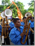
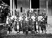
Bamboo Music There are three big ethnics in the island of Sitaro: Siau, Tagulandang and Biaro. Those ethnic living influenced by Sangihe Culture formed habitually and the culture from the ancient to the next generation that it can be exploration. The custom party of “TULUDE” is one of the big and completed events held on yearly. The local smart people served words by ‘MASAMPER” is a harmonies talent of nature singing in a groups. The “Musik Bambu” (Bamboo) and the “Musik Bia” (music tools from shell) is the traditional music. You can find some of traditional dance completed with the custom cloth and also there are symbols of custom usually using by the leaders of custom called “Kasili and Sangiang”

Underwater Tourism

The Echo Tourism. The Regency of the islands of SITARO also is the very exact place to make the echo tourism. The scientist, the academicians and the environmentalist can doing research while making tour. There are a couple of spots waiting for their touch.
The massage spot and to lay on the egg for whale. Lies under the seas of Biaro Island. According to the first research this spot is a place for gathering a school of whale from Pacific oceans, on the marriage and to lay on their egg.
The Coral. On of the marine riches lies almost all of the Regency of the SITARO Islands must be explore. The Paradise for fishing the coral fish easy to reach just take a walk from the border of the beach when low tide, called “Nyare” (local dialect) and also as a source living for local people. The view underwater creature as like as coral bed deposits the exotic nature that never exploit. The seas garden in Biaro Island waiting for exploration by the smart diver.

Marine Tourism

Makalehi Lake Makalehi Island. Lies on the west from Siau Island like a lonely island in the ocean. It deposits a huge fishing potential. You can enjoy the fisherman activity sail on their boat (Pajeko). In the center of the island there is a lake with the unique landscape.
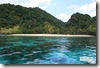
Maharo Beach Mahoro Island. Occupied on the east from Siau Island. The island is heaven for the Wallet Bird. The cave is the home for Wallet Bird as an unique of the nature. White sandy beach and soft lies around the island. This is the best spot for snorkeling and diving.
Pasige Island Pasige Island. This island is unoccopied, little island, diagonal close from Tagulandang island, it’s unique is when the very high tide. This island almost sinking. The heaven of domestic birds and the coral fish in laying their eggs. Good for fishing.

Tour of Nature

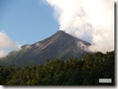
The real volcano of mount Karangetang is the “icon” of Siau Island. The volcanoThe Real Volcano, Karangetang mount called “Custom Mount” (by local people). Deposit a million mystery to research the magma never sleeps from the activity made the top of the mount fire continually serve a unique view in the night. The south of mount, there is a Ruang Volcano Mount, the silent volcano, half of the mount cut off by heavy erupted. This volcano mount is the port of Tagulandang Harbor.
Rare Fauna. There are two species rare in the SITARO Regency “Celepuk Siau” (otus siaoensis) and “Tarsier Siau Island.” The two species is the rare fuana is listed in the WWF. Celepuk Siau is like an owl, in the category of critically endangered. Very exactly doing the tour of nature while trying to identifying both of those fauna.
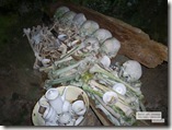
Tembo Yonding Tembo Yonding (Yonding Head). There are a group of skull complete with a million mystery. You can find them in the cave that hang on the stonewall in the Makalehi island. This skeleton is complete and very popular because not all of the people can take a picture in success to develop it. It is very mystery because no one knows this group of the skeleton since the island occupied. Needs to research.


You can check many tourism site of this Regency in here or Tourism Page.


North Minahasa Regency

North Minahasa Regency is a regency of North Sulawesi, Indonesia. The principal town lies at Airmadidi.
Minut Regency 
This area has many tourism potentials such as: Cultural Tourism ie Waruga cultural heritage or ancestral stone grave of Minahasa, Stone grew up in rural Watutumou, and Bull Race. Sea Tourism in Marine Park (Island Ganges, the island Lihaga, Nain islands & Talise Island), a national hero tomb Mother Maria Walanda Maramis, the highest mountain in North Sulawesi, namely Mount Klabat or Tamporok, traditional markets in Airmadidi that sells a variety of specialties Tonsea.
Agricultural resources and coconut plantation are the largest plants in the entire region of North Minahasa. In addition, plant cloves and fruits such as fruit Duku, Langsat, Mangosteen and Rambutan are produced by farmers. North Minahasa mining resources have the potential for large gold wealth.

North Minahasa regency (often abbreviated as minut) with the central government and capital in Airmadidi is located in North Sulawesi Province. This district has a strategic location because it is between two cities of Manado and the port city Bitung. With distance from the center of the city of Manado to Airmadidi about 12 km which can be reached within 30 minutes. Part of the Sam Ratulangi Airport area located in North Minahasa regency (Minut).

This regency is a one of few regency in Sulut that can increase North Sulawesi Tourism's potential in the tourism world.
You can check many tourism site of this Regency in here or Tourism Page.


Minahasa Regency

Minahasa Regency

Minahasa Regency is a regency in North Sulawesi. The principal town lies at Tondano.


Here is a description about Minahasa.
The Minahasa (alternative spelling: Minahassa or Mina hasa) are an ethnic group located in the North Sulawesi province of Indonesia, formerly known as North Celebes. The Minahasa speak Minahasan languages and Manado Malay (also known as Minahasa Malay), a language closely related to the Malay language.
Minahasa Raya is the area covering Bitung City, Manado City and Minahasa Regency, which are three of the seven regional administrations in the province of North Sulawesi, Indonesia.
Originally inhabited by Nuclear Malayo-Polynesian languages-speaking peoples, the region was colonized in the 16th century by the Portuguese and Spanish, then the Dutch. In the Dutch East Indies the Minahasa people identified strongly with the Dutch language, culture and the Protestant faith — so strongly, in fact, that when Indonesia became independent in 1945 factions of political elites of the region pleaded with the Dutch to let it become a province of the Netherlands. There is a considerable number of people from the Minahasa living in the Netherlands, as part of the Indo community.

It is unknown when the land of Minahasa was first occupied by humans. The Minahasans believe that they are descendants of Toar and Lumimuut. Initially, the descendants of Toar-Lumimuut were divided into 3 groups: Makatelu-pitu (three times seven), Makaru-siuw (two times nine) and Pasiowan-Telu (nine times three). They multiplied quickly. But soon there were disputes among these people. Their leaders (Tona'as) then decided to meet and talk about this. They met in Awuan (north of the current Tonderukan hill). That meeting was called Pinawetengan u-nuwu (dividing of language) or Pinawetengan um-posan (dividing of ritual). At that meeting the descendants were divided into three groups named Tonsea, Tombulu, and Tontemboan corresponding to the groups mentioned above. At the place where this meeting took place a memorial stone called Watu Pinabetengan (Stone of Dividing) was then built. It is a favourite tourist destination.
The groups Tonsea, Tombulu, and Tontemboan then established their main territories which were Maiesu, Niaranan, and Tumaratas respectively. Soon several villages were established outside these territories. These new villages then became a ruling center of a group of villages called puak, later walak, comparable to the present-day district.
Subsequently a new group of people arrived in Pulisan peninsula. Due to numerous conflicts in this area, they then moved inland and established villages surrounding a large lake. These people were therefore called Tondano, Toudano or Toulour (meaning water people). This lake is now the Tondano lake.

Minahasa Warriors.
In the following years, more groups came to Minahasa. There were:
  • people from the islands of Maju and Tidore who landed in Atep. These people were the ancestors of the subethnic Tonsawang.
  • people from Tomori Bay. These were the ancestors of the subethnic Pasam-bangko (Ratahan dan Pasan)
  • people from Bolaang Mangondow who were the ancestors of Ponosakan (Belang).
  • people from the Bacan archipelago and Sangi, who then occupied Lembeh, Talisei Island, Manado Tua, Bunaken and Mantehage. These were the subethnic Bobentehu (Bajo). They landed in the place now called Sindulang. They then established a kingdom called Manado which ended in 1670 and became walak Manado.
  • people from Toli-toli, who in the early 18th century landed first in Panimburan and then went to Bolaang-Mangondow
  • and finally to the place where Malalayang is now located. These people were the ancestors of the subethnic Bantik.
These are the nine subethnic groups in Minahasa (which explains the number 9 in Manguni Maka-9): Tonsea, Tombulu, Tontemboan, Tondano, Tonsawang, Pasan Ratahan, Ponosakan, Babontehu and Bantik.
The name Minahasa itself arose at the time the Minahasans fought against Bolaang Mangondow. Among the Minahasan heroes in these wars against Bolaang Mangondow are: Porong, Wenas, Dumanaw and Lengkong (in the war near Lilang village), Gerungan, Korengkeng, Walalangi (near Panasen, Tondano), Wungkar, Sayow, Lumi, and Worotikan (in the war along Amurang Bay).
Until the dominance of Dutch influence in the 17th and 18th century the Minahassans lived in warrior societies that practised headhunting.

You can check many tourism site of this Regency in here or Tourism Page.


Talaud Regency


Talaud Regency ( Islands of Paradise )
Talaud Regency

 A trip to Talaud, has many interesting place to visit. Fabled by the Portuguese as " Porodisa" the green islands, white sands, deep harbor, coral reefs, unique traditional culture island.

 Talaud Regency located between 3 0 38'00" - 50 33'00 north latitude 126 0 38'00" - 5 0 33'00 east longitude,
from Miangas Island in northern part to napombaru Island in southeast part of Kabaruan Island.
 The Position of Talaud Regency in northern part of North Sulawesi which directly border on Philipines.
 Talaud Regency borders on :
North  : Philipines
South  : Maluku Sea
West   : Sulawesi Sea.
East    : Pacific Ocean


 Distance between Manado ( Capital City of North Sulawesi Province) and Melonguane ( Capital City of Talaud Regency ) is 271 Mil, Melonguane- Davao (Philipines) 289 Mil, Melonguane- General Santos City (Philipines) 219 Mil, Miangas- St. Agustin is 50,4 Mil,
Talaud Regency covers area up to 1251,02 km2 with population 84.747 person which divided in to 19 Districts.

Talaud
Talaud consist of three main Islands such as, Karakelang Islands,  a South Island of Salibabu, and South Eastern Mangaran and the remote group of coral atolls far to the northeast, The Nanusa Group.

Karakelang Islands consist of three islands : Karakelang, Nusa Dolom, and Nusa Tofor.
Nanusa Islands consist of eight islands : Miangas, Marampit, Kakorotan, Malo, Mangupung, Intata, Garat, and Karatung.
Salibabu Islands consist of three islands : Salibabu, Sara Besar, and Sara Kecil (Sara Islands).
Kabaruan Islands consist of two : Kabaruan and Naponbaru Island.


Trip to Talaud can be reached by Air, Merpati Air flies to and from Melonguane, or by Ferry's Ship, as Elisabeth, Ratu Maria, Valerine, which depart from Manado Harbour.


Have a Wonderful Trip.


Smile


You can check many tourism site of this Regency in here or Tourism Page.